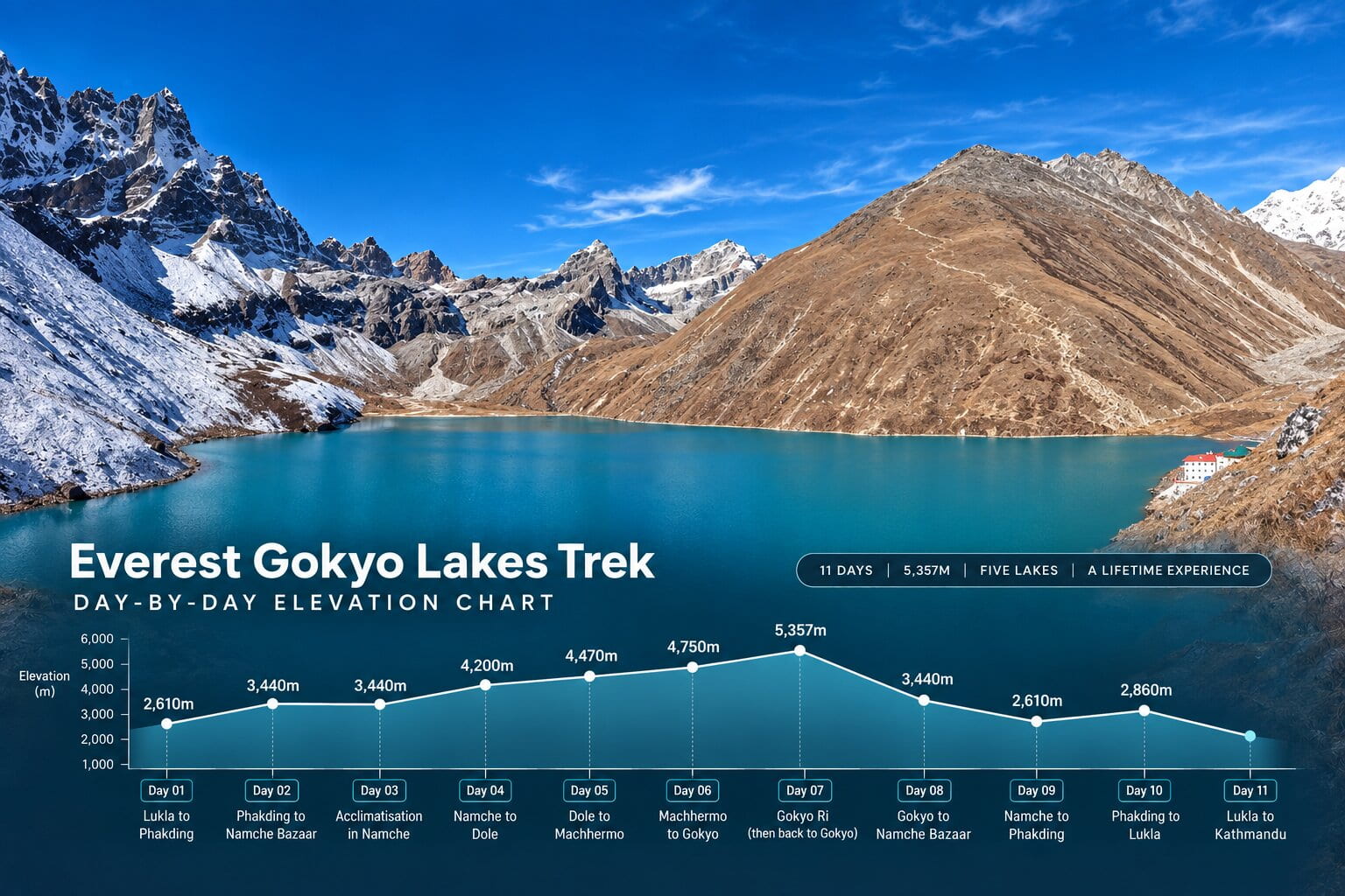
The Everest Gokyo Lakes Trek climbs from Kathmandu (1,400m) to a highest overnight of Gokyo village at 4,750m, with a pre-dawn push to Gokyo Ri at 5,357m — the trek’s highest point. Altitude, not terrain, is what makes this trek genuinely demanding. Two nights above 4,500m and a single-day 760m ascent between Namche and Dole are the two places this route asks the most of your body.
What’s Inside This Guide
- Elevation Profile: Kathmandu to Gokyo
- Highest Sleeping Altitude
- Gokyo Ri: The Trek’s Highest Point
- Why Altitude Makes This Trek Harder
- Acclimatisation Days Built Into the Itinerary
- Signs of Altitude Sickness to Watch For
- How to Walk Safely at Altitude
- Frequently Asked Questions
- Related Planning Guides
Elevation Profile: Kathmandu to Gokyo
| Day | Location | Altitude | Change From Previous Stop |
|---|---|---|---|
| — | Kathmandu | 1,400m | Start |
| 1 | Lukla → Phakding | 2,610m | +1,210m by flight, then descends slightly on foot |
| 2 | Namche Bazaar | 3,440m | +830m |
| 3 | Namche (acclimatisation) | 3,440m | Rest day, day hike to ~3,880m |
| 4 | Dole | 4,200m | +760m |
| 5 | Machhermo | 4,470m | +270m |
| 6 | Gokyo | 4,750m | +280m |
| 7 | Gokyo Ri (day hike) | 5,357m | +607m, returns to sleep at 4,750m |
The steepest single-day sleeping-altitude jump on this route is Day 4, Namche to Dole — 760m in one day. That’s well above the roughly 300–500m per day most altitude-medicine guidance recommends above 3,000m, which is exactly why the trail builds a full rest day at Namche immediately before it.
Oxygen availability drops steadily at each of the route’s key milestones:
| Elevation | Oxygen vs. Sea Level | Trail Milestone | Acclimatisation Status |
|---|---|---|---|
| 2,860m / 9,383ft | ~72% | Lukla Airport | Baseline landing zone |
| 3,440m / 11,286ft | ~67% | Namche Bazaar | Mandatory 2-night stay with active day hikes |
| 4,470m / 14,665ft | ~57% | Machhermo | Staging point before the Gokyo Valley’s highest ground |
| 4,750m / 15,584ft | ~55% | Gokyo Village | Stable two-night sleep zone beside the lakes |
| 5,357m / 17,575ft | ~51% | Gokyo Ri Summit | Maximum altitude reached — brief exposure only, not an overnight stop |
Oxygen percentages are standard barometric-pressure estimates for each elevation, not trek-specific measurements — useful for understanding the trend, not a precise medical figure for any individual.
Highest Sleeping Altitude
Gokyo village, 4,750m — two nights, Day 6 and Day 7. This is the altitude that matters most for acclimatisation, not the Gokyo Ri summit itself, since your body does its real adapting while you sleep, not during a few hours at a higher day-hike point.
For comparison, EBC’s highest overnight is Gorak Shep at 5,164m — about 400m higher than Gokyo’s highest sleeping point. That’s one real reason Gokyo’s altitude profile is a touch gentler than EBC’s, even though the two treks are similar in overall difficulty.
Gokyo Ri: The Trek’s Highest Point
Gokyo Ri, 5,357m, reached on Day 7 before sunrise. You climb roughly 607m from Gokyo village, spend a short time at the summit, then descend back to Gokyo to sleep at the same 4,750m you started from — a genuine climb-high, sleep-same acclimatisation pattern, not a new altitude record for your overnight stop.
This is also the single hardest few hours of the trek physically — a steep, sustained climb in the cold and dark, at an altitude where every step takes more effort than it would lower down. Trekking poles and a slow, steady pace matter more here than on any other day.
Why Altitude Makes This Trek Harder
Air pressure drops as you climb, and with it the amount of oxygen your lungs pull in with every breath. At Gokyo’s 4,750m, roughly 55–60% of the oxygen is available compared to sea level. Your body compensates — breathing faster, heart working harder — but that compensation takes days, not hours, which is the entire reason acclimatisation schedules exist.
Until your body adjusts, ordinary trail walking feels noticeably harder than the same distance and gradient would at low altitude. Sleep is often lighter and more broken. Appetite commonly drops. None of this is unusual on this route — it’s the expected physiological response, not a sign something has gone wrong.
Acclimatisation Days Built Into the Itinerary
- Day 3, Namche Bazaar (3,440m). A full rest day with a day hike to the Everest View Hotel ridge (~3,880m) and back down to sleep at 3,440m — classic climb-high, sleep-low acclimatisation before the trail pushes into the Gokyo Valley.
- Day 5, Machhermo (4,470m). Not a full rest day, but a deliberately short trekking day (3–4 hours) after Day 4’s 760m jump, giving your body extra time at a moderate altitude before Gokyo.
- Day 7, Gokyo Ri climb. A climb-high, sleep-same day — you reach 5,357m but return to sleep at the same 4,750m as the night before, which prepares your body for the descent that follows on Day 8.
Skipping or rushing any of these isn’t a shortcut — it’s the single biggest self-inflicted altitude risk on this route. The itinerary is built the way it is for a reason.
Signs of Altitude Sickness to Watch For
Mild AMS (common, usually manageable): headache, mild nausea, loss of appetite, disrupted sleep, general fatigue beyond what the day’s walking would explain.
Warning signs to report immediately, not wait out: a headache that doesn’t respond to rest or basic pain relief, vomiting, confusion or unusual clumsiness, shortness of breath at rest, a persistent cough, or any symptom that’s getting worse rather than better after a few hours.
The rule that matters most: report every symptom to your guide the moment it starts. Guides on this route are trained to recognise early AMS and will adjust the day’s plan — slow the pace, add a rest, or in a serious case arrange descent or evacuation — well before it becomes dangerous.
How to Walk Safely at Altitude
- Walk at a pace where you can hold a conversation — if you can’t, you’re going too fast for the altitude
- Drink 3–4 litres of water a day from Namche onward
- Eat a full dinner even when your appetite drops — your body needs the fuel more, not less, at altitude
- Avoid alcohol and sleeping pills above 3,000m — both can mask or worsen AMS symptoms
- Some trekkers take acetazolamide (Diamox) as a preventive measure — talk to a doctor before you travel, not on the trail, about whether it’s right for you
- Never continue ascending with worsening symptoms — descent is the single most effective treatment for AMS
Frequently Asked Questions
We don’t recommend it, and most guides on this route will push back if you ask. Day 3 at Namche and the shorter Day 5 to Machhermo exist specifically to manage the pace of ascent — skipping either raises your real risk of AMS higher up the valley, where descent options are more limited.
It’s not mandatory, and plenty of trekkers complete this route without it. Some choose to take it preventively, particularly if they’ve had AMS before or are anxious about altitude. This is a decision to make with a doctor before you travel, not something we can prescribe or recommend generically.
Not reliably. AMS is driven by how quickly your body adapts to reduced oxygen, which doesn’t correlate strongly with cardiovascular fitness — very fit trekkers get AMS and less fit trekkers sometimes don’t. Fitness makes the walking itself easier; it doesn’t meaningfully protect against altitude illness the way the acclimatisation schedule does.
Gokyo’s highest overnight (4,750m) sits about 400m below EBC’s highest overnight (Gorak Shep, 5,164m), and Gokyo Ri (5,357m) is roughly 300m below Kala Patthar (5,644m). The acclimatisation demand is broadly similar, but Gokyo’s altitude ceiling is genuinely a step lower on both counts.
Related Planning Guides
- Everest Gokyo Lakes Trek Difficulty for Beginners
- Gokyo Ri Climb Difficulty
- Everest Gokyo Lakes Trek Cost
- Acclimatisation in Nepal Trekking
- Gokyo vs EBC Comparison
Acclimatise Right, Reach Gokyo Ri
Two nights at 4,750m and a 5,357m summit push are genuinely manageable with the built-in rest days and honest pacing — most AMS problems on this route come from rushing, not from the altitude itself. See the full Everest Gokyo Lakes Trek package → or message us on WhatsApp with any altitude question this guide hasn’t covered.
[…] Everest Gokyo Lakes Trek Altitude and Acclimatization […]
[…] Gokyo Lakes Altitude and Acclimatization — elevation profile and acclimatisation days for the Gokyo side of this circuit […]